Here is a guide on how to create your own .gpx files complete with custom tracks. My tracks often include off road sections so that is specifically addressed here. But maybe we’re getting ahead of ourselves. What is a .gpx track and why do I want one?
Why Do I Need .GPX Files?
GPX files are files that contain location information that can be viewed and edited by various editors and websites. This information is primarily in the form of tracks or single points of interest. For example you might record a track of yourself on a hike. While on the hike you could record points where you had really great overlooks so you could find them again next time.
I find myself wanting to create or edit .gpx files for one of two reasons. I’m either planning a trip and want to make myself a planned route before I leave or I just got back and want to clean up the track before sharing it. I view and collect these tracks on a dash mounted tablet. Here is how to install that.
Google Maps
No mapping conversation is complete without mentioning Google Maps. When making .gpx tracks I frequently use Google Maps to help make lines along established roads. For example if I want to make an overlanding trip map many of the roads will be on recognized roads, even if they are gravel. For that reason I’ll use Google Maps to plan my route (with up to 10 destinations). Then I’ll copy the url at the top of the page for use in GPS Visualizer. If my route will have far more points than 10 then you can break the trip into multiple routes across several pages, then copy and paste each into GPS Visualizer. Just make sure your beginning and end points for the route segments match.
Using Google Maps for this step makes sure your route follows the road well. The alternative is making a track by hand following the curvature of the road which is tedious on a long route.
Note that after July 2018 to use Google Maps route planning in this way on GPS Visualizer you will need a free Google Maps API Key. You can keep the API Key safe and only use it yourself and then you should not see charges. You can get a key here.
GPS Visualizer
Sometimes you just need a track viewer, or something to allow you to make a .gpx file for you to follow (on say BackCountry Navigator). For that I use GPS Visualizer’s draw function. I can make a track either on Google Maps and then import the track url, import multiple source tracks that are .gpx or .kml files, or by hand drawing it on the draw page map itself.
For complex routes I often have elements from all three of these sources that I want to combine into one route. For example I might be able to get Google Maps to
Then I can export a single track as a .gpx file for use in other apps.
GPS Visualizer - Elevation Data Correction
As we all know we now have the ability to record GPS tracks with our phones. But often this data is noisy and mildy inaccurate. Due to that I like to get more accurate elevation data for all the GPS tracks that I record before I share them. The corrected elevation data is from NASA acquired elevation data from a scan in the 1990’s. I use the following page on GPS Visualizer to replace bad data or just add missing elevation data to GPS tracks.
Below are images showing elevation data as recorded and the corrected elevation data. These were trips to Chaos Off Road Park (left) and Assateague (right).
The track at Chaos clearly shows noisy data (blue line) that has been corrected and smooths out (red line). The track from Assateague is interesting because the noisy data (red line) would imply we were crossing 30ft dunes when we knew we were not. The corrected blue shows much more what we were seeing, small differences in height as we moved down the beach.
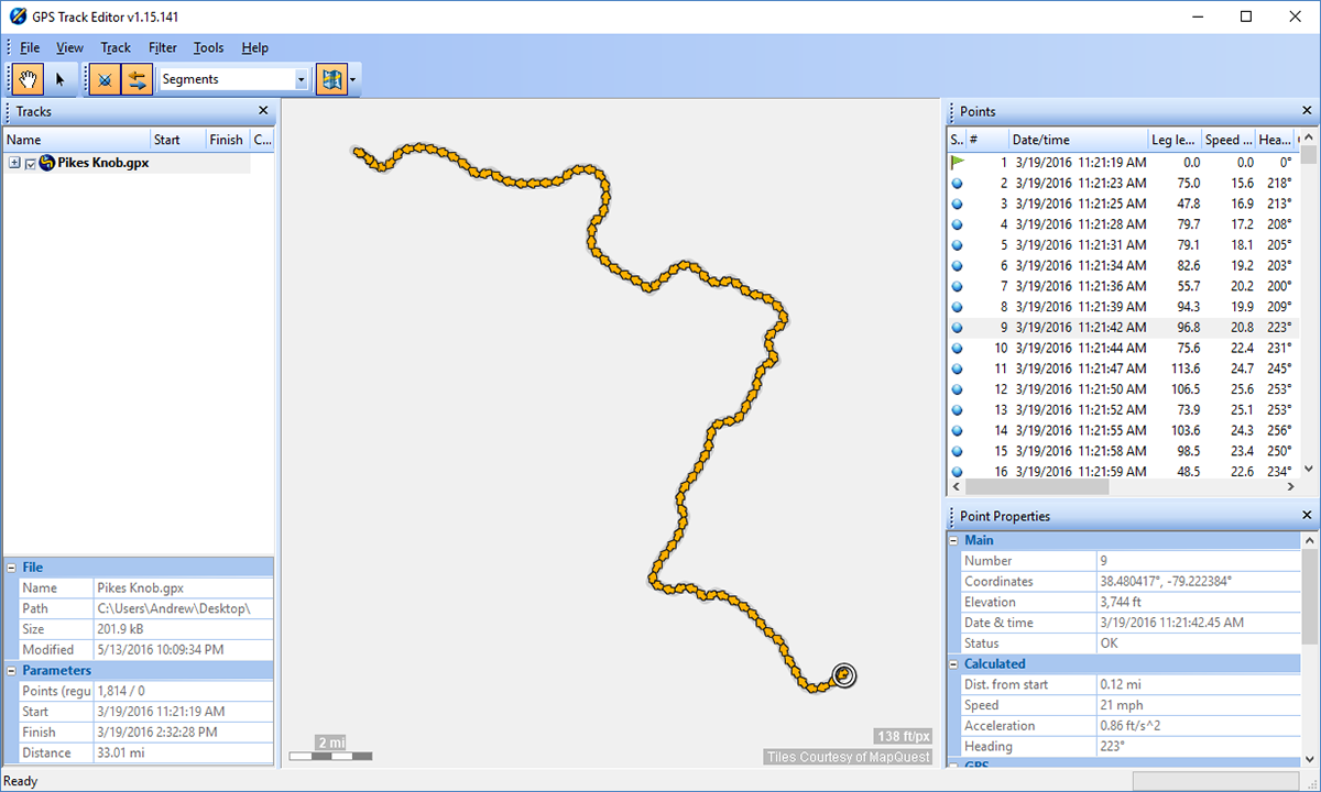
GPS Track Editor
Now you’re home with great tracks but there are parts of the track you want to delete or edit, like if you forgot to stop recording at the end of the day, or wanted to break 1 track into 2 tracks. That’s where GPS Track Editor comes in. It’s a simple to use free Windows program you can download and use to edit tracks and then output new files from.
Navigation Apps
So now you know how to edit and create your own .gpx files! What is the next step. Well if you don’t know how to record them or use the files check out my post covering that here.
