I just got home from a trip to New Mexico. The southwest really is a unique and beautiful place! While I was there I got to revisit two places that I last visited in 2010. The National Museum of Nuclear History in Albuquerque and the San Lorenzo Canyon about an hour south of Albuquerque.
National Museum of Nuclear History
My coworker Justin picked me up from my early Sunday flight into New Mexico. We stopped by El Pinto for lunch, which was spectacular by the way, and then headed over to the museum. The museum has plenty of parking and the $12 entrance fee isn’t bad for what you get to see.
We spent over 2 hours at the museum and had to rush at the end since they were closing. Their collection of artifacts and recreations surrounding the origins of nuclear research are very fascinating. They have a lot of information on the history of various people and places that would play important roles in the work.
Some of my favorite artifacts were the replicas of the first two atomic bombs that were dropped on Japan. I’ve seen replicas like these before at other museums such as the National Museum of the US Air Force in Ohio, but it’s still always thought provoking to stand next to these and think about the events that followed their use. My other favorite exhibit indoors was the collection of nuclear pop culture memorabilia from the 50’s. It was a time when nuclear was a buzzword put on everything!
At the back of the museum are doors that lead outside. Behind the museum is a fenced in area containing larger artifacts such as a B-52 and a F-105. A recent addition that I was not expecting was the conning tower from a nuclear ballistic missile submarine.
My favorite exhibit outside was a surprise as well. They have recreated the tower that held the test article at the Trinity Site, the first nuclear test. While this is obviously a recreation it was fascinating to stand next to it and again imagine a tower like this standing out in the dessert away from everything, nearly 75 years ago. Suspended from the bottom was the culmination of the efforts of thousands of people and years of work that would change the world.
If you’re a military and/or history buff you really should check out the museum if you’re anywhere near the area. It’s a small unassuming building from the outside but it is a very well executed museum.
San Lorenzo Canyon and the Grand Enchantment Trail
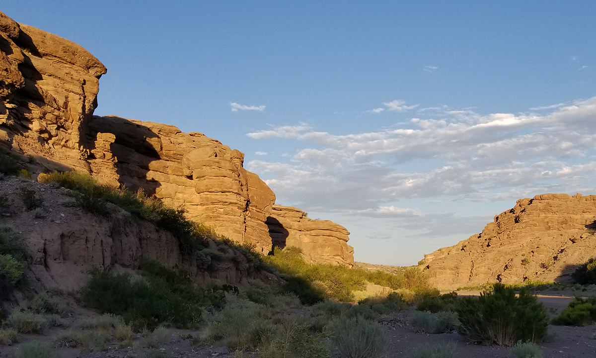
After checking into our hotel and getting dinner we headed back out. Our goal was to find and explore San Lorenzo Canyon. See, I thought I had been to this canyon back in 2010 with some coworkers. But back then I was just riding along with my coworkers and had little idea where we went. I was on a mission to re-discover San Lorenzo Canyon and hopefully find some of the spots I remembered from back then. I also wanted to take advantage of the unique southwest rock formations and capture some pictures at night.
Justin and I made it to the canyon a little before sunset in our F-250 work truck. The drive in from the interstate isn’t bad and we even saw a car in the canyon. You drive down an arroyo for most of the trip from the interstate which was passable by car but the dry silty bottom got soft in places. I would definitely only recommend a 4WD vehicle if there is any hint of moisture in the arroyo as the clay here is very slick when wet.
I set up a GoPro to capture footage of the sunsetting that I could turn into a timelapse. My GoPro camera mount (see more below) worked well to hold the camera stable on a perch of deadwood that I found that gave me the perfect angle.
We hiked off into the main portion of the canyon and left the GoPro to do it’s thing. You can hike about a mile before you get to some large boulders that obstruct the middle portion of the canyon. While we could climb around them, and in the satellite imagery you can see the trail continue, it was getting dark so we turned around.
I captured a handful of pictures on our hike, and we explored off the central path on several spurs. I never found the places that I remembered exploring in 2010 though before it got dark.
Back at the truck I pulled the tripod out and set up for astrophotography. But that’s when I realized my error. Not only was it nearly a full moon, but according to my PhotoPills app the moon was pretty much right on top of the galactic center!!! I took a bunch of pictures as the sun set which I was able to combine into a nice panorama, but the moon was too bright for astrophotography.
I actually made it back to the canyon again two nights later with a different coworker. We filmed the below video with the GoPro attached to the truck drivers side mirror. This is the entire drive from the blocked trail back out to where most people park. This night the canyon filled with owls and bats. It was really neat to hear and see! The moon conditions were basically the same but we did manage to find what I think was the entrance to the slot canyon we explored in 2010. As we discovered it though it was getting dark, so I’ll have to come back to explore it more.
I want to add that I strongly recommend either planning to leave during the daytime or using a GPS tracking app to help you navigate back out of the area. The first night we left after dark and spent about an hour lost on the arroyo, way overshooting our exit path. It’s easy to get lost out there because all the tracks blend together and the bushes and multiple directions the arroyo flows makes it difficult to know which turns you need to take. See our GPS track at the bottom to see how far out of our way we ended up (starting position of track) before driving the whole way back to the canyon just to try to find our way out again from scratch!
Photography/Videography
The GoPro video timelapse really was made a lot easier by the mount I had brought. I used a Shoot Protective Frame for my Hero 6. That was mounted onto a threaded GoPro tripod adapter which I mounted onto a SLR Gorilla Pod.The setup allowed me to bend the Gorilla Pod to rest securely on the very uneven natural surface I set my camera on. The video was edited using CyberLink PowerDirector which I’ve found very easy to use for these kinds of projects.
Driving through the canyon we used the same Gorilla Pod but this time I had my custom camera isolation mount between the camera and the Gorilla Pod. This really did a good job of isolating the camera from the high frequency vibrations from the engine as well as the harder hits from driving around. More on that mount can be found here!
Unfortunately the photography portion of the night really was mostly a bust. I cannot say enough good things about the PhotoPills app which helped me locate the milky way with the moon so bright. Not much to say about the photography except that I used Photoshop to merge the images together in post to get the panorama that I ended up really liking. Not sure why but the way it stretched some of the base images was odd but I’m guessing it was struggling since the bottom portion of all the images was totally featureless in silhouette.