I just returned from an amazing trip to New Mexico again. This time I was down there for a business trip for two weeks back to back but had a long weekend to get out and enjoy everything the state had to offer.
Unlike last time this time we decided to explore the area south of Albuquerque for the entire weekend. This area is especially interesting to me because it lets me find “attractions” that interest me from multiple different directions from where our hotel was. The area offers remote rough roads that require 4WD, dark skies perfect for astrophotography, interesting subjects for photography during the day, interesting land features that I can’t enjoy at home on the east coast, ghost towns with fascinating history, and food that I enjoy that is unique at every turn!
Friday
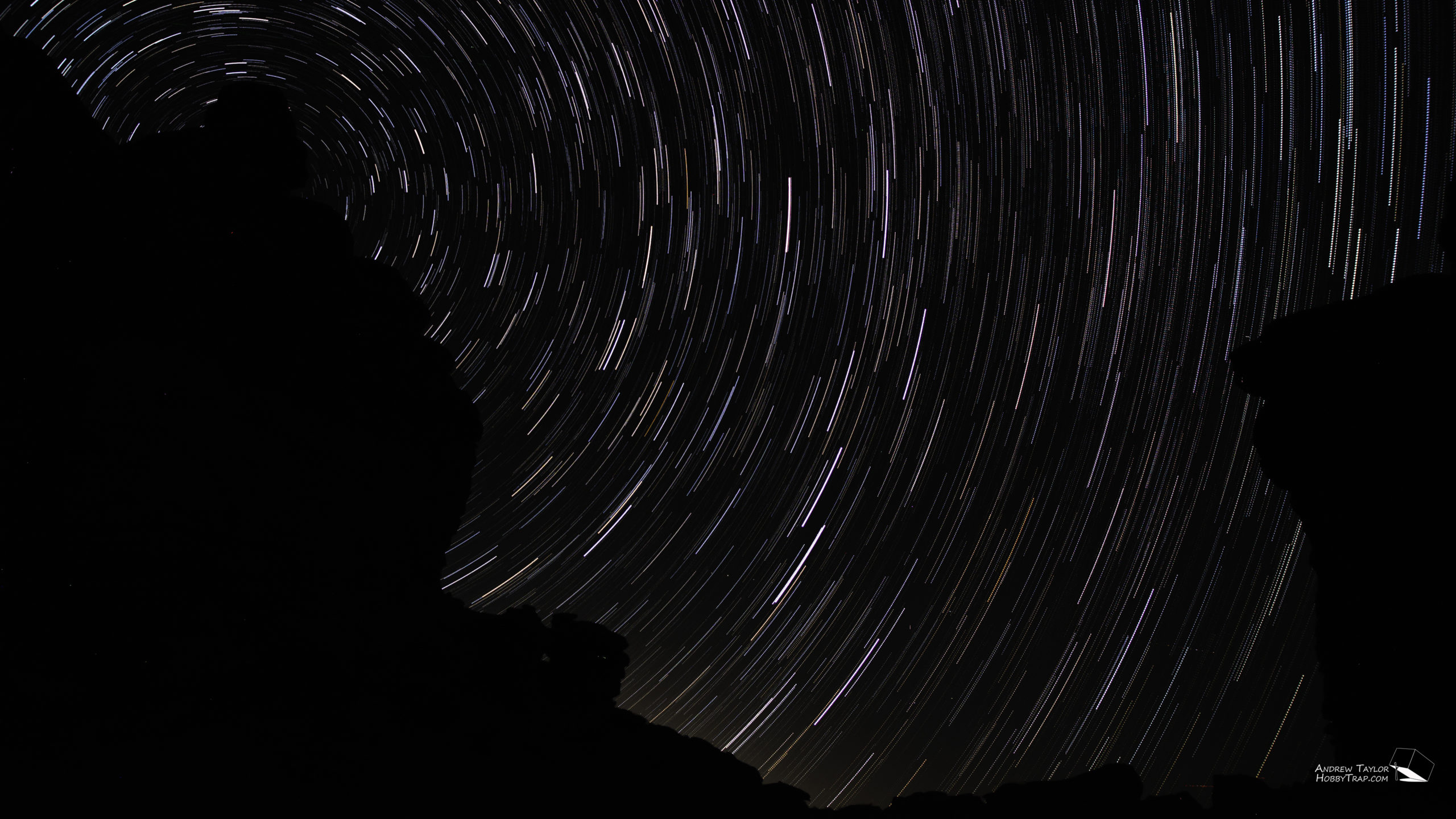
After work on Friday most of our coworkers left leaving just myself and my coworker Wiktor. We decided to start the weekend by heading to the San Lorenzo Canyon for some star trail photography. I have been slowly experimenting with this type of photography, first learning how to use photo stacking software and then more recently getting to try my hand at it again in a better location than my backyard.
We headed to the slot canyon after dinner and aimed to find a location with the slot opening oriented so it would create a canyon on either side of the shot with the camera pointed north, ideally to include the north star within the framing. We found such a location and after figuring out how to use my intervalometer again left the camera taking 15 second exposures every 35 seconds. FWIW this meant setting the camera to a 15 second exposure and telling the intervalometer to take a pic every 35 seconds. Later I read that the reason the camera might have been taking nearly 20 seconds after the shot to finish processing the image was that I had “Long Exposure Noise Reduction” set to on. I’ll have to experiment with turning this off later, although StarStax seems to have no issue stacking my images with 20 second gaps between exposures. But the trails near the edges of the image do show small gaps.
The resulting image is below. It’s my best one to date! I’m not saying it’s spectacular, but I’m excited with how it came out. The images used in this composite were shot using my Samyang 16mm f/2.0 mounted on our Nikon D5100. I shot at 16mm, f2.0, ISO 400. The images were taken over a 30 minute period before my camera battery died. I like that you can see the colors of the stars which I was a little concerned I might not capture at this ISO. I think the light pollution at the bottom of the image actually works well to help define the rocks a little bit. I’m also pleased with my framing, specifically how the north star was well aligned with the rock feature. An area to experiment with next time would be to bring a bright light to try some light painting of the rocks as well, or try similar images on a night with some moonlight.
Saturday
Our entertainment Saturday would involve a visit to the White Sands National Park. On the way we would see what there was to see.
After breakfast and coffee at M Mountain Coffee in Socorro, NM we headed out. Our first stop after getting gas and NM Chile beef jerky was at the Blanchard Rock Shop technically in San Antonio, NM although it’s a good drive from the “city center” as I see it. We decided to stop in because they sold trinitite, a type of glass formed from the sand that was at the site of the first nuclear test back in 1945.
I ended up buy a small piece of trinitite along with a bismuth crystal and a small pile of rocks for Cherie to tumble in her rock tumbler.
Our next unplanned stop was in the Valley of Fires just west of Carrizozo, NM. While driving on highway 380 we crested a hill and suddenly saw an entire valley in front of us that was black. As we drove closer we realized the black is cooled molten lava! It does create a hellish landscape. We stopped by the Valley of Fire Recreation Area to enjoy the sites. It was a very different backdrop for camping and picnicking than recreation areas on the east coast, that’s for sure!
Our next pseudo-planned stop was at the ghost town of White Oaks, with a stop at the No Scum Allowed Saloon! I’m not really sure how it qualifies as a ghost town, there are people there, although there are older buildings in the area. Anyways, after a quick stop for a drink and chat with the friendly bar tender at the local watering hole we headed on. On our way back to the highway we stopped for a large tumbleweed that was crossing our path. We had to stop and get pics… and pick it up… it was sharp and splintery! Lesson learned.
After leaving White Oaks we got on US-54 and headed south toward our destination. This portion of the drive was surprisingly interesting in that it really gave you an appreciation for just how large White Sands Missile Range is! I mean I knew it was big but driving along its eastern edge for over an hour just really gives you a unique perspective of just how big it is. For the hour you are driving parallel to this large open expanse that you know is used for longer range missile tests, and at one point nuclear bomb testing, and you just cant help but be impressed by the capabilities this unique site gives our military. At some point in the future I’ll have to head the whole way down to the White Sands Missile Range Museum.
Our last stop on our way to our destination ended up being Walmart, Arby’s, and a gas station in Alamogordo. We needed fuel for us and the vehicle. And the Walmart had a charger for my DSLR battery which I had somehow left at home. After we were fueled up, and ready to charge up, we headed west to our goal.
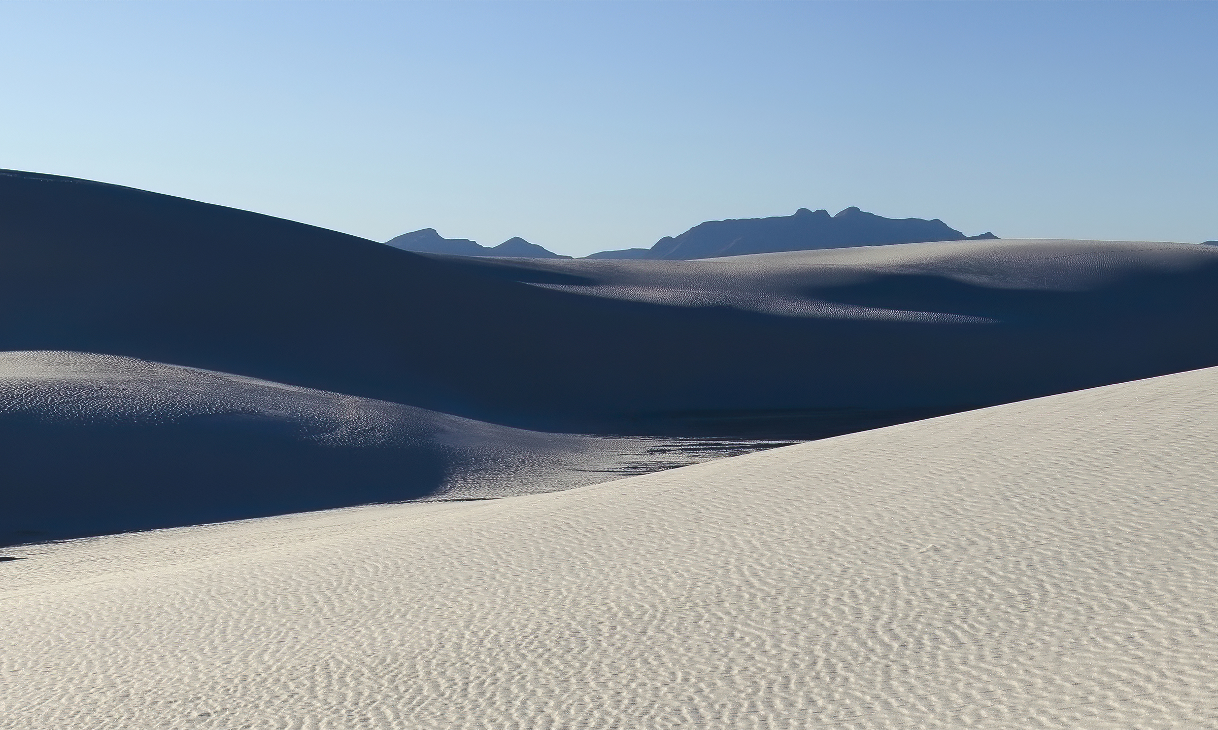
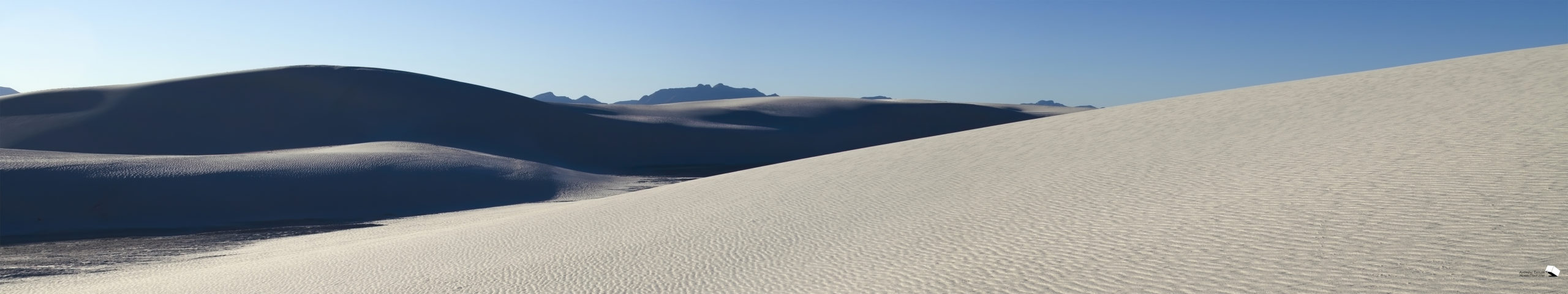
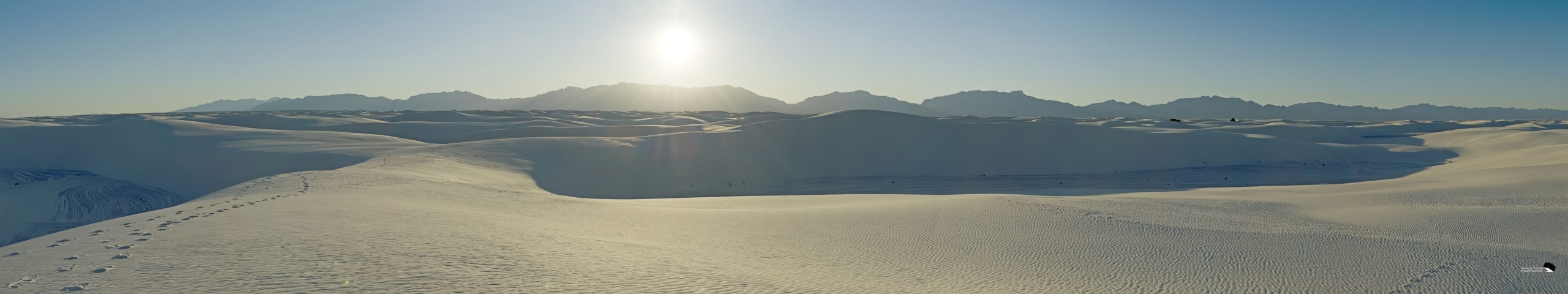
The White Sands National Monument was officially changed to the White Sands National Park with the National Defense Authorization Act that passed in December of 2019. Exciting! After a quick stop by the visitor center and museum we headed out into the park via the Dunes Drive. It was pretty interesting in that the first few miles were paved, and looked recently plowed, but eventually the pavement ended, the dunes got bigger, and the road continued. Basically the National Park “road” is plowed out of the sand dunes, requiring constant maintenance, and providing a unique drive that anyone can do in a passenger car to get to multiple parking areas throughout the dunes. We did most of the loop before pulling off into a parking area on the southwestern corner of the loop.
After grabbing our camera gear we headed out onto the dunes and west to get away from others and hopefully find some unique locations to capture with our camera gear. Many others had remembered to buy sleds, available in the gift shop, and were enjoying sled rides down the dunes around us.
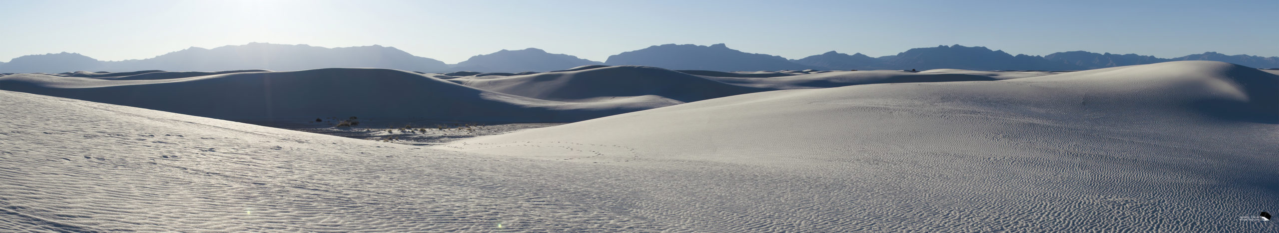
Once you’re about 3 dunes from where you parked it is very easy to get disoriented out there! I just have to assume that everyday they have dozens of tourists that end up lost out there, eventually finding their way back to the road but with no idea which direction their car is! The dunes were a cool gypsum sand, and really was spectacular looking, especially with the mountainous backdrop with the San Andreas Mountains to the west and the Sacramento Mountains to the east.
We left just before White Sands National Park closed at 6pm. Then we had a long drive back to the hotel in the dark. Although the drive wasn’t nearly as scenic as our drive down we did get to enjoy some remarkably clear and dark skies most of the way back… I’m a little jealous of those that get to enjoy this more often…
Sunday
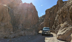
Sunday we stuck a little closer to “home” than we had Saturday. After breakfast at M Mountain Coffee again we headed west toward Magdalena. On the way we briefly stopped at The Box Recreation Area to just see what it was. It’s a pretty neat geologic box canyon but one that would have to remain unexplored by us on this day.
Our first planned stop would be the ghost town of Kelly, NM, just south of Magdalena. We weren’t really sure what to expect. We were not disappointed! Kelly was a mining town with nearly 3000 residents at its peak, mining silver, lead, and zinc. After passing the home that must contain the two new residents who “re-established” Kelly recently we found the remains of the main building, including the headframe. Upon closer inspection a deep mine shaft was still open and a rock dropped down the hole didn’t hit anything for at least 5 seconds indicating the shaft to still be over 400ft deep! I’m glad I didn’t fall in! After taking some pictures we decided to head further up the mountain on one of the routes which appeared to head to another structure according to satellite imagery.
I think we took that F-250 further than most would have tried… but eventually we came to two bushes that would have caused serious paint damage to our work truck so we got out and walked the last few hundred feet. We were treated to another structure near the top of the mountain, complete with machinery surely used to raise material out of the mine shaft just in front of the structure. Sadly the building had some graffiti, but otherwise was in shockingly good condition for a town abandoned in 1947!
While turning the truck around two hikers appeared with their dogs. We got to talking and it turned out the husband was a geology professor at New Mexico Tech in nearby Socorro. They recommended we check out Evetts Café in Magdalena if we were looking for a good bite to eat and a great coffee. We had brought lunch but a fresh hot meal did sound better. We thanked them for the advice and headed back down the mountain. Little did we know we were being swindled and these strangers had a vested interest in that little café!
Lunch at Evetts included a sandwich, chips, and a very good coffee. The menu only had one item, but that sandwich was very good! After eating we got to talking to the owner who pointed out some of his photography was on the walls. They also sold some local made jewelry and children’s books from local authors. Turned out the books were by his Mom. I bought two books for Ethan and we headed on our way.
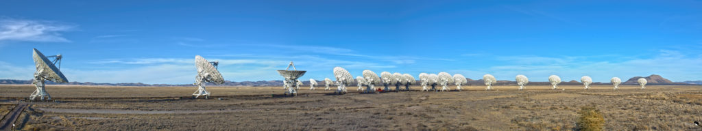
Our next stop was the Very Large Array another 24 miles to the west. The Very Large Array, or VLA for short, is an array of mobile satellite dishes that together form a large radio telescope. The dishes are regularly moved allowing the telescope to shrink to a diameter under 2/3 of a mile and extend up to over 22 miles! This makes it the largest mobile radio telescope of its kind in the world. It also makes it an interesting backdrop for various movies including Contact, The Arrival, and Independence Day.
After paying our entry fee and purchasing Ethan a souvenir t-shirt we were off to get up close and personal with the array. While we got lots of pictures while we were there the trip also confirmed that the array was in its smallest configuration, the worst for me for nighttime astrophotography which would require them to be out closer to the nearest public roads. We did identify an antenna location that I’ll have to make sure to come back to for astrophotography when the array is in the proper configuration!
After our trip to the VLA we headed a little further west to the town of Datil for dinner only to find the restaurant/mart/gas station closed, probably because it was Sunday. So we headed back the way we came and had to stop for a few minutes for a herd of elk that were approaching the road. The delay made it make sense to swing back by the VLA for some sunset pics with the array before heading back toward our hotel.
Since Datil was closed we decided to get dinner in the only other restaurant in Magdalena, the Golden Spur Saloon which advertised they had pizza! Turns out they do, and it’s Digiorno! We ordered some pizzas and drinks and headed to the pool tables at the back to discover the owner of Evetts hanging out with a friend.
He was as surprised to see us again as we were to see him. He asked how the VLA was, and then asked if we had gone to his restaurant after bumping into some hikers that recommended it in Kelly. I said we had and he informed us that the couple were his parents, and that they owned the corner of the building that houses Evetts, and he rents from them. Apparently, his mom felt bad that they didn’t mention their connection to the restaurant that his dad was suggesting! Haha, we thought that was pretty funny! No harm no foul, plus the sandwich was really great!
After dinner we headed back to the hotel, another great weekend day in the bag.
Monday
Monday was a holiday for the local business we were there working with. I got up and made a point to get coffee and breakfast at M Mountain coffee again, along with 4lbs of their Guatemala coffee to take home with me. After tackling some stuff in the morning and joining a few phone calls thru lunchtime we decided to squeeze one more adventure in after Alex from our Salt Lake office arrived.
A local that we’d been working with recommended we check out Forest Road 52 in the nearby Cibola National Forest if we had some free time. I had checked out the area on some maps I had purchased and found that the road would end on Forest Road 549 which would then take us to the top of Mt Withington which was a peak just over 10,000 feet. We headed off to explore the unexplored.
Unfortunately the day was cool and very overcast, a storm that was inbound which would also keep us from being productive on Tuesday. But that didn’t stop us from making it to Forest Road 52. The route turned out to be nearly “Corolla Rated” throughout by my standards but that didn’t mean that the views throughout were not worth appreciating.
The F-250 made quick work of the trail and any small terrain that came our way, all in more comfort than usual thanks to the 2000lb pallet I had had set in the bed before the weekend. We did run into mud/snow in a few spots which I was glad we found on downhills because it was slippery. Those spots convinced me we probably wouldn’t make it to the top of Mt Withington because the top of the mountains were clearly still shrouded in snow and probably ice. Near the intersection with FR549 we came across the Monica Cabin, a cabin apparently available to rangers back in the day so they wouldn’t have to head the whole way back to Magdalena when they were working for multiple days in the field. There were also some indicators that there had been a ropes course at the site fairly recently but it clearly was no longer in operation. There’s even still mention of it on tourist websites (https://www.socorronm.org/attractions/magdalena-mountain-ropes/). We’re not sure what happened to it.
When we arrived to FR549 it was late, but we couldn’t help but see how far up the mountain we could go. We headed south a few miles until we came to a turn covered in ice and snow and decided we’d call it a day. We weren’t trying to do anything stupid, just seeing what we could see. We did stop to check out a few old abandoned truck carcasses along the way though. You have to wonder what their stories are.
We headed back toward Magdalena by heading north of FR549, eventually crossing the VLA train tracks miles from the center of the array. It really gave it some scale because the tracks disappeared off into the horizon with the 27 antennas, each 82ft tall, nowhere to be seen! Only a space this large could hide that array!
I can’t say enough good things about our recreational time in New Mexico, and my trips in the past. The state just has new unique offerings around every corner. I can’t get enough of the landscapes that are so different than those nearer my home, the unique geology, the unique history, the green chile meals three times a day. And I couldn’t get enough of the dark skies and dirt/unimproved roads. I’ll have to come back to try and capture Kelly and the VLA in some night photography, both great subjects. And the more we explored the more I found that I would have to come back to explore more. There are mountain roads crisscrossing all around the area of Kelly, some that lead to the nearby North Baldy peak north of 10,000ft.
New Mexico, I’ll be back!
San Lorenzo Canyon (Friday)
Profile
White Sands Dune Drive (Saturday)
Profile
White Sands Hike (Saturday)
Profile
The Box (Sunday)
Profile
Kelly Ghost Town (Sunday)
Profile
Forest Roads (Monday)
Profile
Disclaimer: I participate in the Amazon Affiliate program. By purchasing items listed on Amazon using the links on this website you are supporting this website. I received no compensation for listing or using any of the products linked to on this page.
